February 7, 2026 — London Heavy rainfall and rising river levels triggered widespread flood warnings across parts of England and Wales on Saturday, forcing road closures, rail disruptions and evacuations in some low-lying communities as emergency crews worked through the weekend to contain the damage.
The Environment Agency issued dozens of flood alerts and warnings overnight after relentless downpours swept across northern and central England. Officials said several rivers had exceeded their banks following nearly 48 hours of sustained rainfall, with more unsettled weather forecast into early next week.
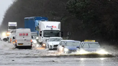
Motorists faced significant disruption on major routes, including sections of the M62 and local A-roads in West Yorkshire and Greater Manchester, where standing water made conditions hazardous. National Highways said some stretches were temporarily closed due to surface flooding and debris, urging drivers to avoid unnecessary travel.
Rail operators also reported delays and cancellations, particularly in the North West and Midlands, where saturated ground and waterlogged tracks reduced speeds. Commuters described lengthy waits and last-minute platform changes as rail staff attempted to reroute services.
Local councils activated emergency response plans in several towns where properties were at risk. In parts of Nottinghamshire and Lancashire, temporary rest centres were opened for residents forced to leave their homes. Fire and rescue services confirmed they had responded to dozens of calls involving flooded basements, stranded vehicles and swift-water rescues.
“We are asking residents in affected areas to remain vigilant,” an Environment Agency spokesperson said. “River levels remain high, and further rainfall could worsen conditions.”
Weather forecasters attributed the system to a slow-moving Atlantic front carrying unusually high moisture levels. While February often brings wet conditions, meteorologists noted that rainfall totals in some regions had already surpassed the monthly average within the first week.
Climate researchers say extreme rainfall events are becoming more frequent and intense due to warming global temperatures. Warmer air holds more moisture, increasing the likelihood of heavier downpours in shorter periods. Recent winters have brought similar episodes of rapid flooding across the UK.
For small business owners in flood-prone communities, the latest surge of water has renewed concerns about resilience and insurance costs. In Hebden Bridge, a town previously hit by major flooding, shopkeepers stacked sandbags and moved stock to higher shelves as a precaution.
“It feels like we’re reliving the same story,” said one café owner whose premises had flooded twice in the past decade. “We prepare as best we can, but it’s exhausting.”
Government officials said funding remains available for affected households under the Flood Recovery Framework if conditions meet the criteria. Local authorities are assessing damage and monitoring river levels hourly.
The Met Office warned that although rainfall intensity may ease later Saturday, catchment areas remain saturated, meaning runoff could continue to swell rivers even after skies clear. Residents living near waterways were advised to check official updates and avoid walking or driving through floodwater.
Community volunteers in several regions mobilised to assist elderly residents and distribute supplies. Social media platforms showed images of submerged fields, swollen rivers and cars stalled in deep water.
As night falls, emergency services remain on heightened alert. Authorities said the priority is protecting life and property while ensuring that transport infrastructure can reopen safely once waters recede.
With more rain forecast in the coming days, attention now turns to whether the current system will evolve into a prolonged flooding episode or gradually move eastward. For many communities, the coming 48 hours will determine the scale of recovery efforts needed in the weeks ahead.